Friday, May 27, 2011

Canyonlands Nat'l Park, Part II: The Needles District 5/17/11

After the haze-filled Island in the Sky experience at the tail end of our 2010 journey to the Canyonlands, we were looking forward to the lower, and presumably more visually pristine, Needles District. Mind you, it's difficult to top the endlessly Grand Canyon-esque visions of the higher planes, but we felt that at least here, we could get out among the formations. Little did we know that one really needs to get out, and not just in a metaphorical sense. Yes, the Needles is, above all, a hiker's paradise, and cars, while welcome, are not catered to in a similar fashion to the park's northern stop. After hitting the visitor center (you'll be lucky if this shabby spot takes more than five minutes of your time), there's precious little road to keep you entranced, and unless you brought your hiking books, backpack, and jugs of water, don't bother even starting out. Backcountry reigns, and the Cales don't do backcountry. Hell, we even try to avoid frontcountry when possible.
Located a good half-hour west from Utah's I-191, Canyonlands Needles is wonderfully isolated in a way impossible to imagine with the more centrally-located, "in the hub" Arches National Park in Moab. This is mean, desolate country, and one feels a bit silly sipping iced tea in an air conditioned motor vehicle while the real people roast alive, risking life and limb. In a sense, we were immediately out of place well before we crossed the park's boundaries; even more so when we looked at the brochure. The trails, ranging from the "modest" Big Spring Canyon to Squaw Canyon route (7.5 miles, 3-4 hours round trip) to the staggering Chesler Park Loop / Joint Trail (11 miles, 5-7 hours round trip), were all ridiculous on their face, though we knew that they were the only real way to see the numerous arches. And what about the four-wheel drive roads? Not in our Dodge Journey, my friends. And if it requires a permit, we automatically assume that we must follow up said permission with a dual casket purchase.
The driving tour, while brief and unsatisfying, was still a reasonable way to spend a late afternoon, as just about everything in Utah is worth seeing with one's own eyes. And in its own way, the Wooden Shoe Arch Overlook was pretty damn cool. We might not go skipping across slick rock with our well-worn walking sticks stabbing the rain-starved dust, but we'll rarely crab in the face of natural beauty. The best of the best was far off in the distance, but we felt that for us, the Canyonlands journey was now as complete as it was ever going to be.
For us, the best part of the Needles District was the little nugget on the way in: Newspaper Rock. While only a single wall (200 square feet), the petroglyphs and ancient scribblings were endlessly fascinating; a collection of rock art extending as far back as 2,000 years. Sadly, Newspaper Rock is a state historic monument, and therefore unconnected to the Eastern National passport program. That said, it contains more striking imagery in its single spot than the entirety of, say, Petroglyph National Monument near Albuquerque, NM. Left by peoples of the Archaic, Basketmaker, Fremont, and Pueblo cultures, the creations range from deer, buffalo, and horses to more human-like figures. There's a modern date or two to show what might happen before official protection, but the rock is surprisingly "clean" of contemporary additions (unlike El Morro, which beckoned travelers well into the 19th century). One doesn't stay very long at Newspaper Rock, but it's a blissful addition to the Canyonlands trek, given that we weren't pitching a tent under the stars, now or ever.

FINAL RATING

6/10

Wednesday, May 25, 2011

City on a Hill: Tuzigoot Nat'l Monument 5/16/11

Tuzigoot - Apache for "crooked water" - is one of the smallest sites in the entire NPS system (those being kind might suggest humble), and, after a long day of similarly themed monuments, not exactly the best way to stir the juices of historical memory. Sitting atop a small hill on the outskirts of Clarkdale, AZ (rising 120 feet above the valley below), overlooking the Verde River, the site is striking to be sure, much like an ancient castle from a long-dead empire, but what glows from afar often withers with proximity. The skeletal remains of a Southern Sinagua village built between 1125 and 1400, Tuzigoot was once two stories high, bursting with 77 ground-floor rooms. Such an edifice no doubt served its purpose of dominating the immediate area (and providing unparalleled views of potential threats), and as said, even the shell hints at its former glory.
The visitor center, as of our visit, was still a work-in-progress; a mess of goodies and artifacts as it improves the museum side of things. As such, we didn't stay long (just enough for me to butcher the stamp, necessitating a second try on another page), and quickly moved to the monument's path. Don't blink, friends, as the walk up is practically the walk back. The area is eye-catching, but the ruins themselves, removed from their perch, aren't much to look at. For perhaps the only time on a visit with ancient architecture, I could see the strings; somehow, these stones just didn't cut it. To some extent, all sites of this type feature fortifications and repairs, but it all seemed too "new" here, and I got the feeling that much of what appears is a modern re-creation, albeit on authentic ground. It did not surprise me to learn that during excavations in the 1930s, walls were stabilized, and the central section was entirely rebuilt.
The brief excursion along the ruins does give visitors a sense of size and scope, but other than climbing to the top, the views remain punishingly the same. Even the bird's eye view is compromised by modern intrusions that reduce the experience to a theme park ride, not a journey into the past. I'm respectful of all NPS locations, but a hint of boredom crept in at Tuzigoot. I had my stamp, my pictures, and snippet of video; now I just wanted to move on. Sure, a guided tour might enhance the experience, but not even the wittiest ranger could inject knowledge into the overall mystery. As always, no one really knows what went on here. Maybe, at long last, it's just one ancestral site too many.
Once again, though, we made amends for passing right by the entrance to this monument back in 2009. Hell, we even saw the ruins from the road! As disappointing as the visit was in 2011, the VC had a few cool bonus stamps. For that, we thank you.

FINAL RATING

2/10

Monday, May 23, 2011

Farewell, Arizona: Navajo Nat'l Monument 5/17/11

It's the end of an era. After two-plus years and thousands of miles, the state of Arizona has been conquered. No, we haven't lifted every rock, nor have we saluted every town and main street, but from the standpoint of passport stamps, it is finished. It's the first state of any consequence on which we've closed the book (we took care of Wyoming in short order, but there's not as much territory to cover), so amidst the sadness, there is joy. Obsessive folks, as we all know, love to cross off that final item from whatever checklist consumes them. We are no different. Admittedly, Navajo National Monument is hardly going out with a bang, given what the Grand Canyon State has to offer, but we'll take it. My heart and lungs will protest, but log it, book it, and let's move forward.
Located twenty miles southwest of Kayenta, Arizona's unofficial stray dog and horse capital, Navajo National Monument is arguably the least enchanting of the region's ruins, primarily because only one of the site's wonders is reasonably accessible to the public. Betatakin (Navajo for "ledge house"), tucked ever-so-logically beneath a canyon alcove, can be viewed from atop the rim after taking the one-mile Sandal Trail. Yes, it is paved and, considering, relatively easy, but the walk back is surprisingly tough. That said, it's important to make that trek, for the view from the back of the visitor center, while lovely, does little to distinguish itself from the eerily similar Canyon de Chelly. Unlike that site, however, Navajo lacks a driving tour, and Spider Rock alone tops anything to be found here.
So one walks down, stares a bit, and eyes the return path with a bit of trepidation. Anything else? One can, theoretically, hike to the bottom of the canyon for a closer look, but tours are ranger-led only, taking up to five strenuous hours. The climb out of the canyon, in itself, is 700 feet. Not in this lifetime, my dear NPS. Not like I'm eyeing your bold-faced warning in the brochure, stating: "If you have heart or respiratory problems, do not attempt this hike." Then there's the Keet Seel ruin (said to be the largest cliff dwelling at Navajo). It may or may not exist, as it's nowhere close to Navajo proper. Hikers not only require a backcountry permit to see it, but they had better be prepared for a 17-mile slog along a "primitive" trail. I can only interpret this to mean that when I drop dead, they'll have to leave my body to the vultures rather than carrying me out. Here, the elevation loss and regain is a staggering 1,000 feet. No question, the pictures of Keet Seel make it extremely appealing, but as I wouldn't seek martyrdom for the awe-inspiring Mesa Verde, I sure as hell won't for a much lesser light of the park service.
At bottom, because of its limitations, Navajo is probably not worth a visit unless completing a stamp run, and at this point, a ruin is a ruin is a ruin. The visitor center is small and shrug-worthy, with displays and random weavers (of the living, breathing variety) spread about with little coherence. Brooke watched the film while I was flopping like a suffocating fish, and while she contends it was fairly decent, I can almost guarantee that I did not need to hear about beans and squash for the umpteenth time. The ancient peoples of the area - Navajo, Hopi, Zuni, and Paiute - deserve our respect and understanding to be sure, but that courtesy does not extend to this monument. Sorry, folks, I'm afraid I'm not overly impressed.

FINAL RATING

3/10

Sunday, May 22, 2011

Life and Death on the Sonoran Desert: Organ Pipe Cactus Nat'l Monument 5/15/11

One is more than prepared for the desolation and danger of Organ Pipe Cactus National Monument, even before once reaches the one-horse town of Why, AZ, or the site's visitor center, named for park ranger Kris Eggle, slain in 2002 while pursuing members of a drug cartel. Highway 86, the only route to the monument from Tucson, is lonely in that way unique to the Southwest, but more than that, it's a virtual graveyard of woe. Along this stretch, drivers will see more descansos - Spanish for "place of rest" - than any other spot in the country. It is no exaggeration to say that these roadside memorials, usually consisting of crosses, flowers, candles, and small religious statues, number in the dozens, some so unusually large that they are difficult to distinguish from an actual burial site. Is travel along this road exceedingly dangerous for any discernible reason? It's not particularly windy, or uneven, or chock full of hairpins, so one must logically conclude that its remoteness, combined with a healthy intake of alcohol, leads to the appallingly high death toll. Somehow, in a manner no less twisted, this is appropriate for the task at hand, as the journey to and through Organ Pipe is not for the timid, ensuring a more suitable reward at trip's end.
The monument itself, so close to the U.S./Mexican border than one can view it well before one reaches the last outpost of Lukeville, is among the most dangerous in the NPS system, hence the heavy presence of border patrol agents and all manner of law enforcement. That said, once one crawls through the checkpoint, they remain all but invisible to the casual traveler, ensuring a trip much superior to the more "city friendly" Saguaro National Park. There, Tucson's protective grip is always present (more so in the Rincon Mountain District), making it a little difficult to surrender to the desert's allure. Organ Pipe presents no such problems, and, if anything, one's most frequent gesture will be to keep checking the gas tank to ensure that one will get out unscathed. Don't assume you can make it back to Ajo for provisions.
Once you drive the few miles down to Lukeville for a quick glance at the border (we left our passports at home this time, so no crossing for us), make your way back to the VC for a choice: the 10-mile North Puerto Blanco Drive, or the 21-mile Ajo Mountain Drive. The former was originally a 53-mile loop, but the standard border "issues" closed all but ten to the viewing public. We chose the Ajo option, if only because, at a greater length, we wanted the full treatment. Because this route is unpaved, allow for 90 slow-going minutes up and along the Ajo Range.
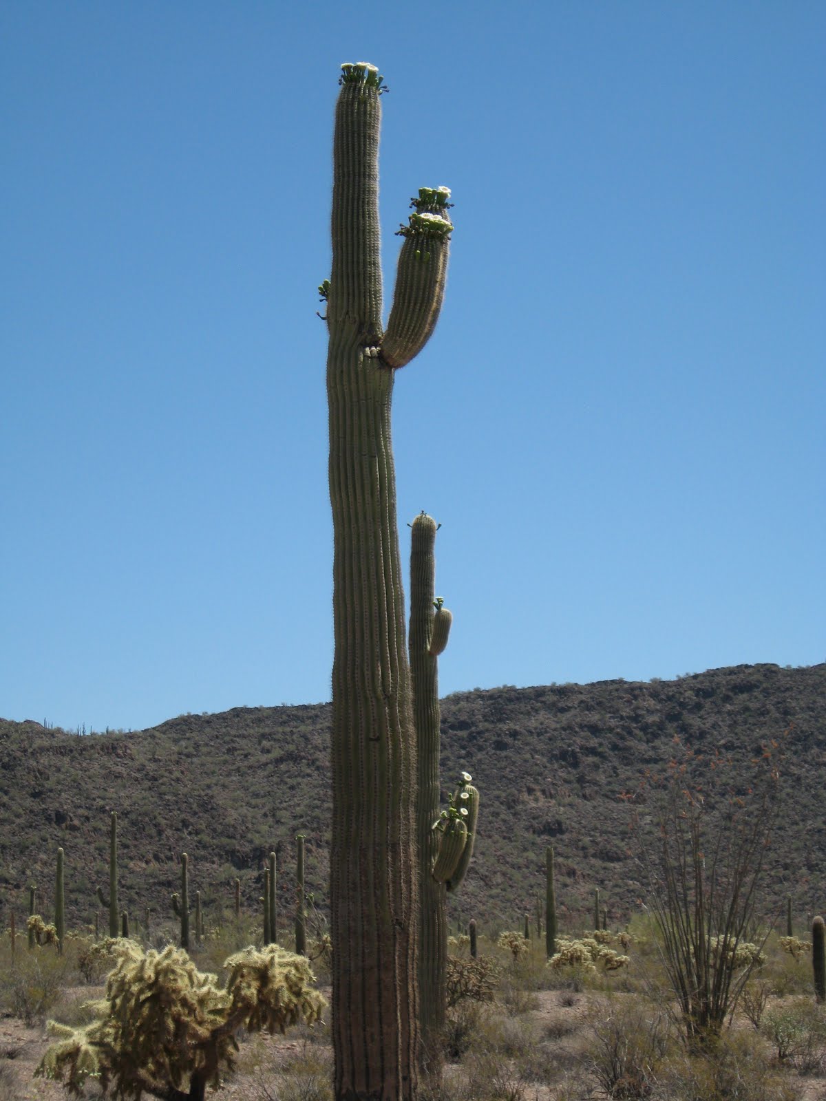
Do not make the same mistake we did at first, assuming that the absence of Organ Pipe cacti would dominate the loop drive. We knew they were relatively rare in the United States, but 
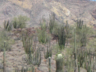
this elusive? Be patient, for as you get closer to the Ajo Range, the site's namesake bursts forth with the expected flourish. Perhaps they lack the singular majesty of the Saguaro, but the Organ Pipe possess a charm all their own. Again, this monument exceeds Saguaro National Park in one chief respect: here, you get both in all their glory, and I'll be damned if there's a cyclist or fellow human to be found. We didn't spot a single car on our drive, and the silence was so blissfully intoxicating that we couldn't help but gulp it all in. There are frequent stops (thanks to the handy - and educational - drive guide called Desert Adaptations), but you can see everything from the car just fine. Hiking might be nice for some, but here, it honestly isn't necessary. And no, we're not just being lazy. The road cuts right through the action, leaving all visitors, even the car-bound, with all they need.
Among the highlights enhanced by the guide include: the prickly pear, jojoba (a waist-high, blue-green shrub), mesquite trees, and the teddy bear cholla. Still, nothing sent our minds reeling more than the chain-fruit cholla, a pale yellow, tree-shaped cacti that feature hanging fruit that forms a long chain. The kicker is best described by the guide itself: "The joints of the plant are biologically designed to detach as an animal is walking by within its spiny reach....The spines are barbed and hook into the coat or flesh of the passer-by and the cholla plant is transported to a new location." To fail to be impressed by the intricacies of evolution after that little piece speaks to a mind that will, alas, never open. But it's all around you - Darwin's theories in full view, unlocking the awesomeness of nature for all to see. It's why we travel so many miles to places few people, let alone water and a hospitable climate, ever see. There are no comforting fables here, only harsh realities. Survival at all costs. The desert on its own terms.

FINAL RATING

9.5/10

Saturday, May 21, 2011

Not from a Disney Story: Montezuma Castle Nat'l Monument 5/16/11

569,000 visitors in 2010. Compare this to the visitations for the Top Ten Least Visited Sites in the National Park system, and Montezuma receives more than all ten sites combined. It is not a shrinking violet in the NPS annals, and the proximity from the oft-traveled Hwy 17 between Flagstaff and Phoenix, AZ is without question the reasoning behind the tourist numbers.
Truth be told, this was our second visit to Montezuma Castle in two years. It was this very site where the passport stamp first came to our attention. So, since this obsession has all but taken over our lives, it seemed apropos to return to the initial scene of the crime. Full disclosure, however - the pictures on this entry are combinations from both trips. We had blue skies in 2009 and partly cloudy skies this time, so your eyes do not deceive you.....

We traveled to Montezuma Castle after our harrowing Tonto National Monument adventure. The temperature dropped to an unseasonable 66 degrees, and our patience was at its limit. Curse the random driver deciding to hold us up after our 2 1/2 hour trek on an unpaved dirt road. We were ready to rock....A drive through beautiful Payson, AZ led us to a side highway that easily brought us to Montezuma Castle.

The large parking lot was completely full. A smattering of families dragging their unwilling children jaunted towards the visitor center, along with the senior citizen crowd, comprised the majority of the visitors this day. The queue to pay the $3 per person fee was running out the door (!), and equipped with our America the Beautiful National Parks Pass, allowing us free access, we skipped it altogether, shortchanging the 2011 visitation numbers by two.


Native American ruins, while ubiquitous, can also be difficult to access for the casual traveler. Ardous hikes along gravel and unpaved roads can make these spots tricky to see. Montezuma Castle is thankfully NOT one of those cases. All comers are able to view the monument at the same pace as the most fit and hearty. A flat, short trail brings you to the only view of the Castle. Tours up until the 1950s allowed visitors to climb up unsteady ladders and explore the monument, but erosion stopped the practice.

The castle itself is a five-story, twenty-room structure dating from the 1100s. Standing 100 feet from the small valley, it surely must have been a convenient site to spot incoming enemies, but a difficult climb to make several times per day. The fertile valley below offered an ideal location to plant the squash, beans, and corn that fed the Sinagua.

Besides a short walk around the perimeter of the valley, the visit to Montezuma Castle is brief. However, the site of the Sinagua's irrigation water, Montezuma Well, is approximately eight miles up Highway 17 and is a separate site of the NPS system (complete with another passport stamp - more on that later).

A short, steep staircase leads to the "well", which is the result of a collapsed limestone cavern. The water is heavily inundated with carbon dioxide, making it uninhabitable for life (except the most hearty bacteria and adapted fish), but perfect for the crop irrigation the vegetables needed.


An online blog spoke of the small ranger station at the bottom of the hill. A warning of it being sporadically manned was given. We watched the ranger walk away with a photographer as we pulled in. Hoping it would be a brief absence, we pressed our noses against the glass, gazing at the stamp that eluded us. We waited in the car, hoping the ranger would return, but to no avail. We closed our passport book, and headed to Tuzigoot.

Montezuma Castle should be stopped at if you are traveling between Phoenix and Flagstaff. It is an easy drive, walk, and experience to stand in the shadows of a castle much unlike Cinderella's, but no less grand.


FINAL RATING

6/10

Friday, May 20, 2011

The Road Not Taken: Fort Bowie Nat'l Historic Site 5/14/11

We were not going to drive by this place again. As recently as March, we came within shouting distance of Fort Bowie's entrance, only to pass on by because, well, we had to make Tucson by sunset, and we sure as hell didn't have time for a long hike. You see, we had always assumed that the only way to the site (and visitor center, the location of the precious passport stamp) was via a not-so-easy 3-mile round trip romp through brush, rocks, and nests of unforgiving rattlesnakes. Neither of us were suited for such an event as fainting and baking underneath a humorless Arizona sun, so we checked our urges and left the whole thing for another day. Then, thanks to the forum on the endlessly helpful website parkstamps.org, we learned that there was (gasp) another way. A handicapped access road, you say? Would there be spotters checking for placards? Armed guards turning away sneaks and cheats who dared avoid a bit of exercise? We had no idea, but as our next trip approached, we knew we had to give it a shot. If we could avoid three full miles of huffing, puffing, and frantic calls to the paramedics - and secure a stamp - we were willing to use all the secret handshakes and under-the-table bribes to get it done.
First of all, the above image is not the official park sign. How could it be, since we skipped the parking lot and trail, and turned that blissful left onto a road reserved for those who needed assistance to walk 500 yards. Oh, and it was a particular coup to learn that one could turn into the site from Interstate 10, rather than drive to Willcox for the much longer detour. So much for internet "information." The road from the interstate is not, as sources claim, "treacherous," nor is it hard on the car. It is, however, a huge time-saver, and we're thankful to have trusted our guts and not some website. After driving a short distance, the fork in the road appears, which we would not have seen had we come from the other direction. Three miles to the back door? That's it? We could practically smell the decaying fort from our front seats.
Once safely tucked into the privileged parking lot, we walked a harder-than-it-looks slope to the crest of a hill, where the visitor center beckoned our non-weary souls. We were not sweaty, or tired, or cramped and grouchy. True, by avoiding the traditional hike, we missed the route of the Butterfield Stage, the site of a wagon train massacre, and a cemetery (apparently, a Medal of Honor winner is buried there), but we had unlimited access to the ruins themselves, which is what brings this site a level of distinction. As the day was blissfully blue and relatively pleasant, we were instantly able to recognize the fort's isolation within a harsh, brutal environment. Because there are no reconstructions like, say, Fort Laramie, the sense of days gone by really captures the visitor. With only the shell of a once-great fort before you, it's not difficult to believe that above all, history is a narrative steeped in sadness.
After all, what was Fort Bowie but a guns-blazing community dedicated to the eradication of Native peoples? As the brochure tells us, "Between 1862 and 1886, Fort Bowie was the nerve center for military campaigns against hostile Chiricahua Apaches led first by Cochise and then by Geronimo." In a sense, the site's preservation is the flip side to the Indian ruins that dot most of the Southwest. While those NPS destinations celebrate the mystery and complexity of America's first inhabitants, a place like Bowie chronicles their final, ignominious end. Fort Bowie is the very spot, in fact, where Geronimo was brought after his final surrender in September of 1886. A picture of the once proud warrior (located among the ruins) reduces him to a mere prisoner; powerless, bereft, and a symbol for the humiliation to come. How appropriate, then, that we see mere walls left to the elements, the clamor of soldiers now reduced to a quiet breeze.
Admittedly, there is not a lot to see at Fort Bowie, and for those looking to "walk where they walked" and eye the daily activity of a 19th century soldier, you might leave disappointed. Much is left to the imagination, and the experience will become whatever a person brings to it. As such, it's a site for symbolism and reflection, not immersion. The modern world does not intrude here, as it should be, but the visitor center does not go the extra mile to provide historical context. The Battle of Apache Pass also occurred here (the event that led to the fort's construction), and we are treated to the typically rugged terrain this part of Arizona is known for. The story is likely more complete for those who survive the longer walk, but that must be left to the hearty. Sure, we played it safe and cannot lay claim to a full "earning", but at least we can put this site to bed, as it no longer mocks us from our dog-eared Rand McNally.

FINAL RATING

5/10